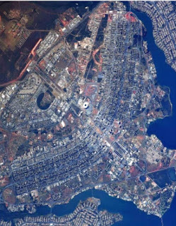
Satellite images show amazing intricacy of the world's most eye catching 'planned' towns and cities
Imaginative layouts make some urban areas as distinctive from the sky as they are at ground level
Designs show the skills of city planners over hundreds of years - from the Renaissance to the 1960s
At first glance some of these extraordinary satellite images could be mistaken for bizarre works of modern art rather than towns and cities that are home to millions of people.
From the elegant
bird-shaped design of Brazil's capital Brasilia, to the circles and
intricate diagonal grid pattern of downtown Washington DC - some of the
greatest urban spaces on Earth look almost as distinctive from space as
they do at ground level.
And the ingenuity of the architects who planned and designed them through the ages, from the Renaissance to the 1960s, can still be seen today.


0 comments:
Post a Comment